What are geographical coordinates?
Coordinates are a method to quantify a location on a spheroid map model of the Earth, corrected for the fact that the earth is not a perfect sphere. In order to get the coordinates of a geological marker, you must first find its location on this map model. In our case, the map model is Google Maps/Google Earth, WGS84.
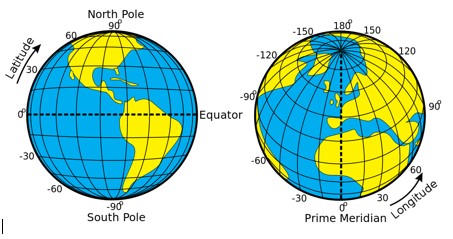
Latitude in degrees is the North-South measurement, which is positive (designated by N) in the Northern hemisphere above the Equator. The Twin Cities is around N 45 degrees. Longitude in degrees is the East-West measurement, which from Greenwich, England is negative going West (designated by W). The Twin Cities is near W 93 degrees. Ref.http://www.geographyalltheway.com/ks3_geography/maps_atlases/longitude_latitude.htm
Angular measurements are shown in degrees. Degrees may be sub-divided into smaller units two ways: degrees minutes seconds (DMS) or in Decimal Degrees. One method may easily be converted into the other (https://www.fcc.gov/media/radio/dms-decimal ). GPS devices conveniently allow for the selection of many of these different units, as do many smartphone apps.
The fineness of a degree measurement is dictated by the sub-division of seconds (DMS) into decimals: (ex.: 44°57'03.0"N, 93°08'45.0"W). The more decimal places, the finer and higher resolution the measurement is. The sub-dividing of degrees alone gives Decimal Degrees, for which the resolution may be made finer by the addition of more decimal places. For this project the minimum number of decimal points is one decimal for seconds in DMS and six decimals in Decimal Degrees.
Latitude and Longitude formats for the Marker Survey
For this survey of geologic markers, we will use the following coordinate formats in the table below. The following reference is good for the conversion of many different formats. http://www.earthpoint.us/Convert.aspx#PositionColumn
|
Value |
Description |
|
Latitude |
Latitude of point. Google Earth uses the WGS84 geodetic datum. Valid formats include: If expressed in decimal form, northern latitudes are positive, southern latitudes are negative. |
|
Longitude |
Longitude of point. Valid formats include: If expressed in decimal form, eastern longitudes are positive, western longitudes are negative. |
Measuring Latitude and Longitude: Devices
Measuring location coordinates may be done with a GPS device (selecting for WGS84 or WGS83: Google Maps) or an A-GPS smartphone app like the Google Maps App or another suitable app using WGS84. Both device types use satellite locations in the sky, and, added in the case of the smart phone, cell towers and WiFi. It may take time to lock onto satellites or cell towers to get good readings, about five to fifteen minutes.
The reported accuracy** of a single reading for a good GPS device is, depending on the model, within 10 feet 95% of the time. Accuracy for smartphones (iPhone in this case) using A-GPS and Google Maps is within 54 feet, 95 % of the time. For both device types, the precision gets better with multiple readings by averaging the latitudes and the longitudes separately (seconds in DMS or the Decimal Degrees).
Although the reported smartphone measurement above is more variable, a large geological marker will probably be easy to spot within 54 feet, much like using a street address with a smartphone GPS to find a building.
Taking a Good Latitude and Longitude Measurement
For a good, understandable coordinates reading:
- Do some practicing at home to understand your GPS or smartphone
- Include with your data the brand/model of your GPS or smartphone and its App. Include the accuracy as the number of decimal point on the coordinates
- Ensure a clear view of the sky, note if there is cloud cover
- Avoid tree cover, buildings, and ferrous metals in the ground or nearby.
- Don’t put the device on the ground, especially if wet
- Set a GPS to WGS84 datum to be compatible with Google Maps
- Give the GPS or smartphone time to stabilize to get a satellite lock (5 min. minimum)
- Move 30 feet away from the target marker location and move back again for multiple readings
- Take five samples, one every 5 minutes and average
- Take an average of two devices if possible
- With a smartphone, if the reading is difficult, but the location on the Google Map is clear, drop pin to find the map coordinates and report both coordinates measurement and the map location coordinates
- Because they do not give resolution to less than a second, do not use Apple Maps or the iPhone compass.
The Use of a Smartphone Google Maps App for Marker Location Coordinates
There are many compass and geocaching apps for a smartphone that give within a tenth of a second accuracy, and which to use is a personal choice. The simplest is to use the Google Maps App, the one many people use for traffic directions.
The Google Maps app on an IPhone or iPad does not automatically give the coordinates of a selected location (a dropped pin) like the computer Goggle Maps internet website, https://maps.google.com/ . Here is a YouTube reference for using Google Maps App to give the coordinates of a marker: http://youtu.be/HgL_PzImfO0
To use the smartphone Google Maps app to find coordinates
- Open the Google Maps App
- Clear the search box, choose the view: satellite or terrain
- Spread the image to magnify the location as much as is legible for marking a spot
- The “Blue spot” is your location
- Drop a pin on the blue spot by holding a finger of the location
- Go to the bottom of the screen where it says “Dropped Pin” and tap to select. If it gives an address, you will not get coordinates. Move finger until you can get “dropped pin”.
- Tap the “share” icon on
- Choose “message” for SMS text or “mail” for email
- Enter the address to send it (to yourself)
- Go to the received message : there are two addresses in the message, choose the second Http://goo.go//------- address at the bottom
- Google Maps then will open with the decimal coordinates at the top search box (example: 44.938845,-93.146033) and the degrees coordinates at the bottom box (example: 44o56’19.8”N 93o08’45.7”W)
- Record coordinates.
**Accuracy References: Note the mixed the units of meters and feet
There is a lot of confusion on the accuracy of hand-held device coordinates measurement. The accuracy as reported above was to calculate the RMSE (root mean square error) of the measured locations around a target location, very much like a bullseye target. A one RMSE diameter circle is around the target center containing 68% of the measurements. This is inside a two RMSE diameter circle containing 95% of the measurements. In 2009, the RSME for a GPS was about 1.5m (2 RMSE’s giving 95% at 10 feet) and for an iPhone was about 8.3m (two RMSE’s giving 95% at 54feet). It is probable that this has gotten better with app improvements over the years.
http://www.paulzandbergen.com/files/Zandbergen_Barbeau_JON_2011.pdf